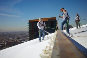
GARANTIAMO MASSIMA PROTEZIONE DURANTE I LAVORI IN QUOTA.
Missione sicurezza
Siamo una squadra di professionisti che si occupa di mettere in campo tutte le risorse e le soluzioni necessarie per assicurare la massima sicurezza di coloro che lavorano in quota. Il nostro obiettivo è diffondere e trasmettere una cultura della prevenzione degli incidenti. Ci riconosciamo in un ottica di servizio a 360° con un atteggiamento focalizzato al problem solving: dalla consulenza alla progettazione, dall'installazione all'assistenza, fino all'ispezione e revisione degli impianti anticaduta o DPI. Vogliamo essere il partner in grado di assistervi in tutte quelle realtà professionali che necessitano di assistenza e consulenza nel settore del rischio caduta dagli amministratori di…
Leggi tuttoRecent Posts
2020
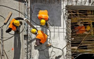
Protecline Surface
Un nuovo servizio dedicato ai sistemi di verniciatura Dopo aver maturato una lunga esperienza nel settore dell'edilizia e delle costruzioni,…
Read More2019
Nuove regole DPI: cosa cambia con il D.LGs 17/2019
Previste più sanzioni (fino a 150 mila euro) e norme più chiare per la fabbricazione e la commercializzazione dei dispositivi…
Read More2019
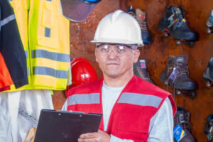
Servizio di ispezione periodica dei D.P.I. e delle attrezzature complesse
Protecline ha ottenuto l’abilitazione come da art.77 del D.Lgs. 81/08 Come previsto dal Testo Unico per la Sicurezza sul Lavoro…
Read MoreUtilizzando il sito, accetti l'utilizzo dei cookie da parte nostra. maggiori informazioni
Questo sito utilizza i cookie per fornire la migliore esperienza di navigazione possibile. Continuando a utilizzare questo sito senza modificare le impostazioni dei cookie o cliccando su "Accetta" permetti il loro utilizzo.